Hydro

Hydro systems make electricity from flowing water.

Building a hydro system is a substantial undertaking, but once installed, it will generate electricity when it is needed most (during winter and during periods of wet weather) and if carefully maintained, it will last for many decades.

Please call us on 07792 319313 to discuss your site. If it looks promising, we can arrange to carry out a feasibility study. We offer a much more comprehensive feasibility study than most other companies. For example, we obtain quotes for key items including turbine, pipe and grid connection and we submit an Environment Agency hydropower pre-application form. The feasibility study will estimate the capex, opex, revenue and return of the scheme and will recommend whether or not to proceed.

Feasibility
Project management
Grid connection application
Environmental permitting
Outline design
Planning
Design
Build

If the feasibility study recommends proceeding, we can then quote for the development phase. This includes applying for the necessary Environmental permits and planning permission. A flow measurement campaign is also sometimes included, along with any design work necessary at this stage.

Once all permissions are in place, we can quote for the installation phase.

To see if you have a viable site, we first need to determine the available head and flow. We can do this as part of a feasibility study, but if you have time, you may wish to measure or estimate these parameters and then work out the likely rated power yourself using our hydro calculator. If so, please read on.

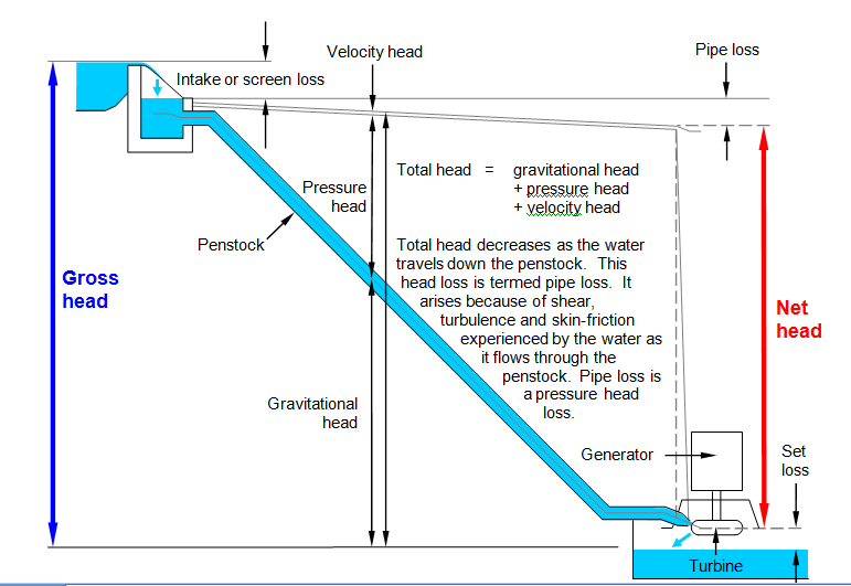
Gross head is the drop of water from the proposed intake location to the proposed outfall location and is measured in metres (m). We usually measure gross head with a dumpy level and staff. Net head is equal to gross head less intake and pipe or channel losses. We aim to keep these losses below 10 % of the gross head through careful system design, so as a first approximation, net head = 0.9 x gross head. A feasibility study would determine head losses more accurately.

The diagram below shows the losses that make up the difference between net head and gross head.

Flow obviously varies throughout the year, but for our purposes, we need to find the mean flow over a long period, say 10 years or more. We also need to know the flow duration, i.e. how the flow varies over that period. Flow is measured in cubic metres per second (m3/s). There are many ways to measure flow. Our usual method is to plot the catchment as a polygon using an Ordnance Survey map, then run this catchment polygon through a software program called LowFlows 2. The outputs from this program are reasonably accurate estimates of long term mean flow and flow duration for the site. LowFlows 2 takes into account local rainfall, evaporation, geology and other factors.

Spot gauging is another way of finding the mean flow and flow duration. We often use spot gauging to verify our LowFlows 2 estimates. For sites with mean flows up to 100 litres per second (= 0.1 cubic metres per second), this can be done by installing a V-notch weir, then recording the date, time and water level above the apex of the V-notch at regular intervals. The recorded water levels can then be converted into flows using the formula for flow over a V-notch weir. Instructions for building your own V-notch weir and generating spot gauge data (date, time, water level and flow) can be found here. Many other methods are available for generating spot gauge data. Different methods are appropriate for different types of watercourse. Once you have collected enough spot gauge data, it can be correlated with fifteen-minute flow data from a nearby Environment Agency gauging station on a representative catchment. This correlation will yield a flow factor, which can then be used to scale the Environment Agency data to the site, thereby giving an estimate of the long term mean flow and flow duration at the site.

We offer a desk-based flow analysis and site appraisal for less than 1/3 of the cost of a feasibility study. Please ask about this service, as the price will vary with the size of your catchment. The maximum or rated flow of the turbine is usually chosen to equal the mean flow in the watercourse, though in some circumstances it can be more and in others less, e.g. if there is a limit on the amount of power that can be fed into the grid at the proposed point of connection and a grid upgrade to allow more power to be fed into the grid would be prohibitively expensive. For now, we will assume rated flow = mean flow.

The rated power, or maximum electrical power of your hydro system, is then calculated as follows:


If your scheme comes out at more than 100 kW and there is local demand for the power, then it may be feasible. Smaller systems can also be feasible in certain circumstances, e.g. if most of the infrastructure is already in place (e.g. from a previous hydro scheme at the site) or if the scheme is a waterwheel, which adds æsthetic value to a property.

Hydro calculator coming soon…